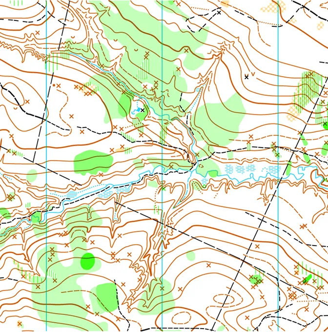
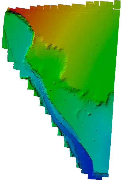
Contours and elevation models
DTMs, surface models and contours at the interval your designers are working to, in your project coordinate system.
Survey-grade topographical mapping by drone, RTK/GNSS or both — contours, DTMs, orthomosaics and CAD-ready terrain outputs for engineering, planning and setting-out across Kenya.
Most projects we see start with a vague idea of what's actually on site. We turn that into a measured base map — using drone photogrammetry, RTK/GNSS rovers, a total station, or some mix of all three depending on what the site, the canopy and the deadline call for. Levels, edges, drainage lines, existing features — what's there ends up in the data.
You get DWG, DXF and GeoTIFF, plus the supporting reports — opened straight in AutoCAD, Civil 3D or QGIS without rework. We've done this for half-acre plots and 40-kilometre corridors. The approach scales; the control discipline doesn't change.
Standard packs for engineers, project owners and consultants. Formats and layers are agreed before the campaign so nothing comes back for cleanup.
DTMs, surface models and contours at the interval your designers are working to, in your project coordinate system.
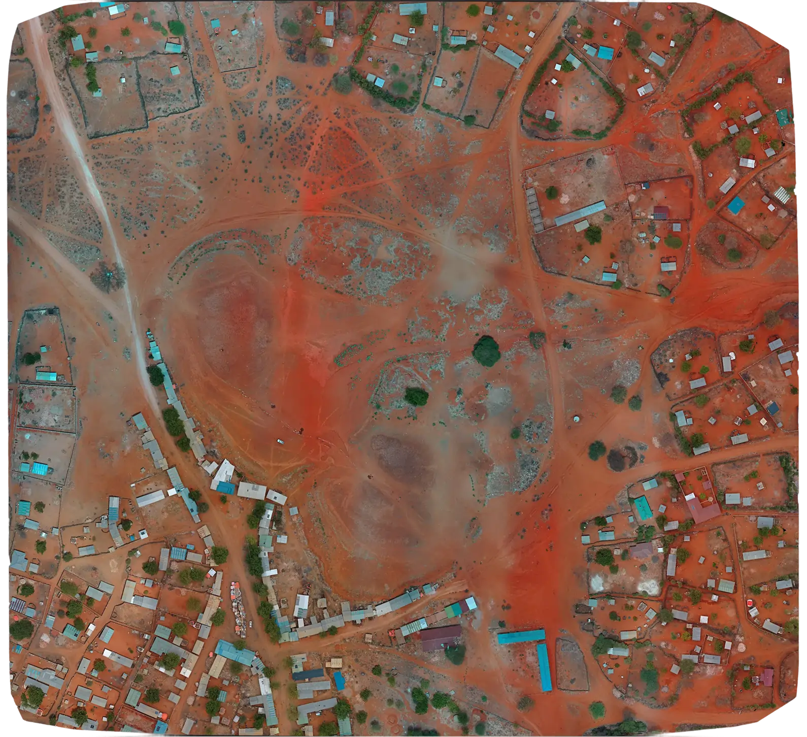
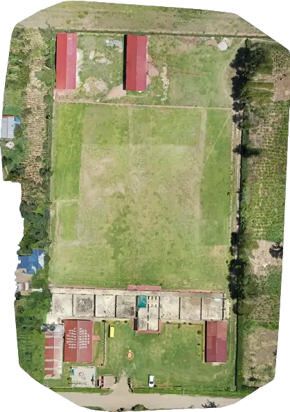
A georeferenced site image at sub-5 cm pixel size. Boundaries, access, vegetation and structures all show up at scale.
DWG, DXF, SHP and GeoTIFF, with layer names you can actually find. A short note travels with the files so the recipient knows where everything is.
A short report covering control point locations, RMS values and the checkpoints we held back for validation. Useful when somebody asks where the numbers came from.
Every job looks slightly different. The four moves underneath are the same.
Boundary, deliverables and coordinate system are agreed before anyone leaves the office. Control strategy comes out of that.
On-site flying and ground control, with flight height and overlap chosen for the resolution you actually need.
Photos and control go through processing. We pull independent checkpoints, look for gaps and artefacts, and sign off only when the numbers hold.
Files come over in the agreed formats, with a one-pager so your CAD or GIS lead knows what's where.
Usually the first thing a project asks for, and the thing every later decision rests on.
Route design, drainage review, setting out — long corridors get the same treatment as compact sites.

Subdivisions, housing schemes, mixed-use sites — anything that needs a base map before architects start.
Catchment work, stormwater design and flood modelling, with terrain data clean enough to feed straight into the model.
Topographical surveys that include boundary verification — beacons, fences, existing features — alongside the terrain mapping. Often bundled with a formal boundary survey.
Topo work is a means to an end — the right tool depends on the site. Some jobs get flown, some get walked with GNSS, some need a total station, most need a bit of each.
Mavic 3 Enterprise RTK and Phantom 4 RTK are our usual workhorses, with a Mavic 2 Pro for smaller jobs. Live RTK where the GSM coverage holds, PPK where it doesn't.
Multi-frequency receivers running on NTRIP corrections. They set the control, pick up the things the drone can't see clearly (manhole rims, kerb inverts, corner pegs) and validate the model after.
Dense urban sites, sites under canopy, anywhere GNSS gets blocked — the total station does the work. Same survey, different toolkit.
Pix4D and Agisoft for the imagery side. Civil 3D, Global Mapper and QGIS for the contours, breaklines and the layered DWGs your designers actually want to open.
Multi-site programmes, road and pipeline corridors, development properties — captured fast from the air, tied down with proper ground control.
A few we've delivered recently — corridor work, multi-site programmes, a campus, a ranch. Open any one to read the brief, the approach and what was handed over.
Quick framing for clients who haven't commissioned a topographical survey before, or who are weighing whether to fly the site, walk it, or both.
A drone covers ground a two-person crew can't realistically reach in the same window. A 50-acre site that takes a week with a total station typically lands as a measured base map in two to three days end-to-end. The catch is canopy, wires, dense built-up areas — anything that hides the ground from the air. Where that's the picture, we walk the site instead.
We don't really treat them as alternatives. RTK GNSS and a rover pick up the things the drone can't see; the drone fills in the open ground at sub-5 cm pixel resolution. Most projects get both.
Every survey we deliver is tied to documented control. Checkpoints are held back from the adjustment, so the residuals in the report are independent — not the points the model was solved on.
On open ground we typically land ±3–5 cm horizontal and ±5–8 cm vertical, in whatever CRS your project is using. Tighter than that, we densify control.
Engineers shouldn't be cleaning up survey data. CAD layer naming, contour intervals, breakline policy and CRS are agreed before fieldwork starts — so the DWG opens in Civil 3D with the right pen weights, and the GeoTIFF lines up in QGIS without re-projection.
BIM-led project? Mesh export alongside the DWG. GIS-led? SHP/GPKG with the attribute schema populated.
Quick answers to the things clients usually want to know before we start a survey.
Honestly, both, on most jobs. Open ground gets flown for coverage; the same site gets walked with GNSS or a total station to pick up what the drone can't see — manhole rims, kerb inverts, fence lines under trees. Heavy-canopy or built-up sites lean more on the ground crew; flat, exposed sites lean more on the drone. Either way the deliverables look the same.
On open ground, with proper RTK control, the data is comparable — typically ±3–5 cm horizontal and ±5–8 cm vertical against held-back checkpoints. The difference isn't accuracy, it's coverage. A drone records every visible point on the surface; a ground crew samples representative ones.
Roughly: 2–3 days end-to-end for a 50-acre site, 1–2 weeks for a small estate or development, 4–6 weeks for corridor work in the 100–200 km range. Weather, access, the level of feature digitisation you want and the CRS you're working in all shift this around.
A CAD-ready DWG/DXF with contours, breaklines, spot heights and feature linework; a high-resolution orthomosaic; a DTM and DSM as GeoTIFFs; SHP/GPKG vector exports if your team is GIS-led; and a short control and QA note covering RMS values and the held-back checkpoints. Layer naming and contour interval are agreed with you before the survey runs.
Arc 1960 / UTM Zone 36S and 37S, WGS84 / UTM, local construction grids, or whatever CRS your design team is using. Files come out as DWG, DXF, SHP, GPKG, GeoTIFF, LAS or PDF — with layers named to match your project standards.
Yes. We've delivered a single 185 km pipeline corridor and a 60-site programme spread across five counties. Mission planning, control density and processing parameters get standardised across sites so the deliverables come back consistent — modelling and design teams can work straight off them.
Yes. We hold a Remote Operator Certificate (ROC) issued by KCAA, fly under a documented safety case, and coordinate any extra approvals (BVLOS, controlled airspace, ATC notifications) when a project needs them.
Country-wide. Recent campaigns have run in Turkana, Marsabit, Wajir, Kiambu, Kajiado, Nakuru, Uasin Gishu, Laikipia, Kilifi and Nairobi. Field crews mobilise out of Nairobi; processing and CAD production happen there too.
A site boundary or KMZ, what the data is for (design, planning, statutory submission, monitoring), the CAD/GIS deliverables and layer standards you need, the target coordinate system and contour interval, and a deadline. With those, you'll have a fee, mobilisation plan and timeline back within 48 hours.
Other things our team gets brought in for, often on the same projects.
We hold the regulatory approvals and supplier partnerships required to deliver compliant, audit-ready geospatial outcomes across East Africa.

