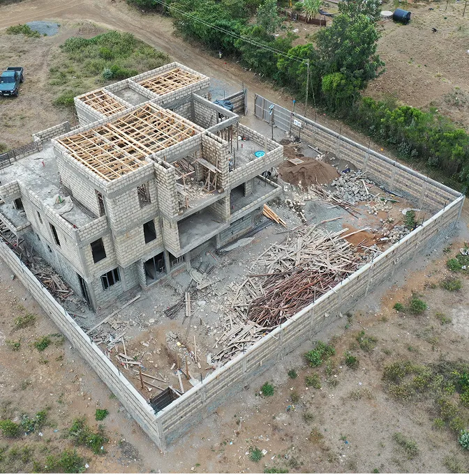
Aerial photo and video updates
Site visuals captured from fixed viewpoints so changes read clearly week to week.
Repeat aerial capture that turns construction into a clear, measurable timeline.
Site updates that arrive as a WhatsApp photo and a verbal summary tend to argue with each other. We fly the same paths and the same heights every cycle, so this week's data sits cleanly next to last month's.
What lands is a record stakeholders agree on: visuals for the boardroom, orthomosaics for the contracts manager, and surface models when the question is how much earth has actually moved.
Light packs for communication. Heavier ones when the conversation is about quantities and contracts.
Site visuals captured from fixed viewpoints so changes read clearly week to week.
Georeferenced site maps. Drag two dates side by side and the difference is obvious.
A short pack with annotated images, observations and the items worth flagging — the kind your project manager forwards on.
Surface models and volume outputs when earthworks, stockpiles or borrow areas need numbers.
Drone-captured as-built documentation comparing the constructed state to the design intent — useful for handover, payment certification and dispute resolution.
The first flight matters most. It sets everything that follows.
We lock in flight paths, viewpoints and reporting format on the first visit. Every cycle after copies the recipe.
Weekly, fortnightly or pegged to milestones — whichever rhythm matches the project.
Each cycle is processed, compared with the last, and turned into the visuals or measurements you asked for.
You get the cycle pack. The full archive sits behind it — a defensible record if it's ever needed.
Most useful when more than one team needs the same picture of the same site.
Earthworks, structures, materials, access. The whole site, on a schedule.
Roads, water, energy. Long sites where driving the line every week isn't realistic.
Visual reports for people who don't read technical drawings.
Project owners use these flights to sign off variations, settle disputes and track risk. One clean record of progress beats arguing over phone photos.
Other things our team gets brought in for, often on the same projects.
We hold the regulatory approvals and supplier partnerships required to deliver compliant, audit-ready geospatial outcomes across East Africa.

