Volume reports
Net and gross volumes for each stockpile, excavation or earthworks zone — with the calculation method, base surface and accuracy statement documented.
Precise stockpile, cut-fill and earthworks volume measurements by drone and GNSS — for quarries, mines, construction and waste management.
Whether the question is how much aggregate is sitting in a stockpile, how much earth has been excavated this month, or whether a contractor's claim matches reality, the answer is a volume. We fly the site, process a surface model and compute volumes against a base surface, a previous epoch or a design surface — whichever the project calls for.
Drone-based volumetrics replace tape-and-truck estimates with measured, auditable numbers. The same survey can feed inventory management, progress certification, royalty reporting and regulatory compliance.
Volumes alone aren't enough — you need the surface models, the methodology and the audit trail behind them.
Net and gross volumes for each stockpile, excavation or earthworks zone — with the calculation method, base surface and accuracy statement documented.
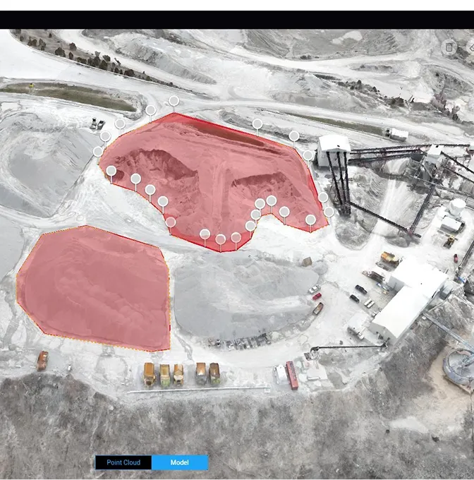
The DSM and orthomosaic behind the numbers. Useful for visual verification, site planning and comparison between epochs.
Colour-graded cut-fill maps showing where material has been added or removed relative to a design surface or previous survey.
Repeat surveys turned into a time series — volumes by date, by zone, by material type — for inventory management or contractor certification.
One flight, one surface model, one set of numbers that everyone agrees on.
We confirm the stockpile zones, the base or reference surface, and how the volumes will be reported.
The site is flown and controlled. Flight height and overlap are set for the surface detail the volumes demand.
Surface models are built, checked against control, and volumes are computed using the agreed method.
Volume reports, surface models and supporting files are delivered. For repeat programmes, each cycle drops into the same tracking format.
Anywhere the question is 'how much?' — and the answer needs to be defensible.
Stockpile inventory, extraction tracking, royalty reporting and regulatory compliance volumes.
Cut-fill progress, contractor certification, borrow-pit tracking and site formation monitoring.
Remaining capacity, fill-rate tracking and environmental compliance reporting.
Volume disputes cost more than volume surveys. We deliver numbers with the surface model, the control report and the methodology note — so when someone asks 'where did that figure come from?', the answer is in the pack.
Straight answers for quarry managers, project managers and engineers.
On well-controlled sites we typically achieve ±1–3% of the true volume, validated against independent checkpoints. The main variables are ground-control density, surface texture and how well the base surface is defined. For high-value stockpiles we densify control to tighten the number.
It depends on throughput. Active quarries and large earthworks sites often run monthly. Construction projects align surveys to payment milestones or contractor claims. We set up a repeat programme so each cycle is directly comparable to the last.
Photogrammetry measures what it can see. If stockpiles are partially vegetated we can switch to LiDAR for better ground penetration. For water-filled pits, we combine drone surface data with bathymetric soundings to close the volume.
A topographical survey maps the terrain for design. A volumetric survey quantifies how much material sits above or below a reference surface. The capture is similar — often the same flight — but the processing and deliverables are different. We often deliver both from one campaign.
Other things our team gets brought in for, often on the same projects.
We hold the regulatory approvals and supplier partnerships required to deliver compliant, audit-ready geospatial outcomes across East Africa.

