Classified point clouds
Dense LAS/LAZ files with ground, vegetation and structures separated. Open in CloudCompare, ReCap or whatever your team already uses.
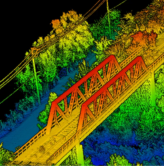
High-density 3D capture for vegetated corridors, complex terrain and any site where photogrammetry leaves gaps.
Photogrammetry needs texture and light to triangulate from. LiDAR doesn't. The pulse goes down, finds something, comes back. That's how we get clean ground returns under bush and canopy, on dark surfaces, or where the sun decided not to cooperate that morning.
We fly LiDAR for engineering corridors, forestry blocks and quarry sites. The output lands as classified point clouds, bare-earth DTMs, contours and the cross-sections engineers are reaching for — not just a pretty visual.
What you take away depends on whether the question is engineering, environmental or asset-driven.
Dense LAS/LAZ files with ground, vegetation and structures separated. Open in CloudCompare, ReCap or whatever your team already uses.
The ground stripped of canopy and shrub. Drainage, design and volumes all work cleanly off it.
Contours at the interval that matches your drawing. Cross-sections and longitudinals for corridor work.
Raster, vector and point-cloud formats sized for QGIS, ArcGIS or your CAD station — not a generic dump.
LiDAR is unforgiving when the basics are skipped. The basics here aren't skipped.
We walk the brief — terrain, vegetation, accuracy target, end-use — before settling on platform and point density.
GCPs, checkpoints, altitude, overlap and scan settings come from one number: how dense the cloud needs to be.
Raw scan data is registered, cleaned, classified and held against control. We don't move on while the numbers are off.
Clouds and derived products land in the formats your GIS, CAD and engineering software actually want.
Pick LiDAR when you can't trust the visual.
Roads, powerlines, pipelines — the bush is hiding the ground and we still need a profile.
Earthworks, drainage, slope analysis. Numbers that hold up in design review.
Canopy structure, understory and bare-earth in one capture. Useful for management plans.
We don't hand over a 70 GB folder and disappear. Classified clouds, terrain models, contours and profiles arrive as a usable package, with a short note on what was held back as check.
Other things our team gets brought in for, often on the same projects.
We hold the regulatory approvals and supplier partnerships required to deliver compliant, audit-ready geospatial outcomes across East Africa.

