Drone-based mapping in Kenya has moved well beyond simple aerial photography. Today, two core sensor technologies dominate commercial survey operations: photogrammetry (using high-resolution cameras) and aerial LiDAR (using laser scanners). Both produce accurate 3D representations of terrain and features, but they work very differently and excel in different conditions.
Choosing the wrong sensor for your project can mean weeks of rework, unusable data under tree canopy, or deliverables that don't meet your engineer's accuracy requirements. This guide gives you a practical, side-by-side comparison based on real project experience across Kenyan terrain — from Nairobi's dense urban fabric to forested highlands and open rangelands.
How Photogrammetry Works
Photogrammetry uses a high-resolution camera mounted on a drone to capture hundreds or thousands of overlapping photographs of the ground. Specialised software — such as Pix4D, Agisoft Metashape, or DJI Terra — identifies common features across overlapping images and uses triangulation algorithms to reconstruct a dense 3D point cloud and a georeferenced orthomosaic (a seamless, scale-accurate aerial photograph).
The key requirements for good photogrammetric results are sufficient image overlap (typically 75–80% front overlap and 65–70% side overlap), consistent lighting, visible ground texture, and accurate georeferencing through ground control points (GCPs) or an RTK/PPK GNSS system on the drone.
Modern survey-grade cameras like the DJI Zenmuse P1 (45 MP full-frame sensor) or the senseFly Aeria X achieve ground sample distances (GSD) as fine as 1–2 cm per pixel at typical survey altitudes, producing horizontal accuracies of 2–3 cm and vertical accuracies of 3–5 cm with proper ground control.
How Aerial LiDAR Works
LiDAR (Light Detection and Ranging) works by emitting thousands of laser pulses per second from a sensor mounted on the drone. Each pulse reflects off surfaces — the ground, vegetation, buildings, power lines — and returns to the sensor. By measuring the time each pulse takes to return, the system calculates precise distances and builds a dense 3D point cloud.
A key advantage of LiDAR is that laser pulses can penetrate gaps in vegetation canopy. In a single pass over a forested area, a LiDAR sensor may record multiple returns per pulse: the first return hits the tree canopy, intermediate returns hit branches and understory, and the last return reaches the bare ground. This allows the software to classify and filter points, producing a bare-earth digital terrain model (DTM) even under dense vegetation.
Survey-grade drone LiDAR systems like the DJI Zenmuse L2, RIEGL miniVUX, or YellowScan Mapper achieve point densities of 100–500+ points per square metre and vertical accuracies of 2–5 cm. Combined with an RTK/PPK GNSS-INS (Inertial Navigation System), they deliver reliable georeferenced data without requiring as many ground control points as photogrammetry.
Accuracy: How They Compare
In open, well-controlled conditions, both technologies can achieve similar absolute accuracies — typically 2–5 cm horizontally and vertically. The difference emerges in challenging environments.
Photogrammetry accuracy depends heavily on image quality, overlap, lighting, and the presence of visible ground features. On featureless surfaces (water, uniform sand, freshly graded earth) or in shadows, the software struggles to find matching points, leading to gaps or reduced accuracy in the point cloud. Under tree canopy, photogrammetry simply cannot see the ground at all.
LiDAR accuracy is less affected by lighting conditions (it works in shade, overcast skies, and even low-light environments) and is not dependent on surface texture. It performs consistently on bare earth, grass, rocky terrain, and under vegetation. However, LiDAR does not capture colour or texture — it produces geometry only. For projects that need both accurate terrain data and visual imagery, many operators fly both sensors simultaneously or on consecutive flights.
Vegetation and Canopy Penetration
This is the single biggest differentiator between the two technologies, and it matters enormously in Kenya where significant portions of project sites — tea estates in Kericho, forest reserves in the Aberdares, mangrove zones along the coast, riverine corridors in the Rift Valley — have moderate to dense vegetation cover.
Photogrammetry captures what the camera can see. If the ground is obscured by trees, bushes, or tall crops, the resulting DTM will represent the top of the vegetation, not the actual terrain surface. This makes photogrammetry unsuitable for bare-earth modelling under canopy without extensive manual editing or supplementary ground survey.
LiDAR's multiple-return capability allows it to map both the vegetation surface and the ground beneath it. On a typical forested site, a LiDAR survey can produce a canopy height model (CHM), a digital surface model (DSM), and a bare-earth DTM from a single flight mission. This is invaluable for forestry assessments, environmental baseline studies, flood modelling through vegetated river corridors, and infrastructure route planning through wooded terrain.
For open sites with minimal vegetation — quarries, construction sites, open farmland, solar-farm sites — the canopy-penetration advantage of LiDAR is irrelevant, and photogrammetry delivers comparable terrain accuracy with the added benefit of full-colour imagery.
Deliverables: What Each Technology Produces
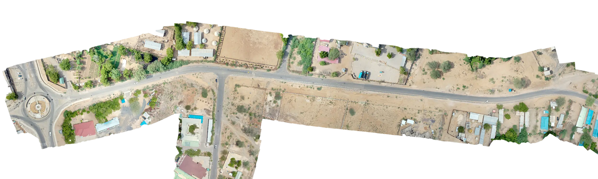
Photogrammetry produces: georeferenced orthomosaics (high-resolution aerial maps with true colour), dense 3D point clouds, digital surface models (DSMs), contour maps, 3D textured meshes, volumetric calculations, and — with multispectral cameras — vegetation indices like NDVI for agricultural analysis. The visual richness of photogrammetric outputs makes them ideal for client presentations, planning submissions, and GIS platforms.
LiDAR produces: classified 3D point clouds (ground, vegetation, buildings, power lines), bare-earth DTMs, DSMs, canopy height models, contour maps, cross-sections, and intensity images (greyscale representations based on surface reflectivity). LiDAR data integrates directly into CAD and engineering design software for earthworks calculations, flood modelling, and corridor analysis.
For projects that require both visual context (orthomosaics) and accurate bare-earth terrain under vegetation (DTMs), the best approach is often to fly both sensors — either on the same drone using a combined payload, or on separate missions. The photogrammetric orthomosaic provides the visual layer, while the LiDAR provides the geometric precision.
Processing and Turnaround
Photogrammetric processing is computationally intensive. A 100-hectare site flown at 2 cm GSD can produce 3,000–5,000 images, requiring a high-performance workstation with a powerful GPU and 64–128 GB of RAM. Processing time ranges from several hours to over a day depending on the dataset size and the level of detail required. Cloud processing platforms can accelerate this but require uploading large datasets.
LiDAR processing is generally faster because the sensor produces the point cloud directly — there is no image-matching step. The raw data is georeferenced using the GNSS-INS trajectory, classified (ground, vegetation, buildings), and exported. A 100-hectare LiDAR dataset can typically be processed in one to three hours on a standard workstation. However, LiDAR data does require careful quality control: checking trajectory accuracy, verifying ground classification, and removing noise points.
For time-critical projects — emergency assessments, rapid environmental baselines, construction progress monitoring — LiDAR's faster processing pipeline can be a significant advantage. For projects where visual outputs are the primary deliverable, photogrammetry remains the natural choice.
Terrain and Project Type Suitability in Kenya
Choose photogrammetry for: open construction sites and earthworks monitoring, agricultural mapping and crop health analysis (especially with multispectral sensors), real-estate and property marketing aerials, quarry and mine volumetric surveys on exposed rock, urban mapping where visual context is important, and any project where a colour orthomosaic is the primary deliverable.
Choose LiDAR for: forested and vegetated terrain where bare-earth data is required, corridor mapping for roads, pipelines, and power lines through wooded areas, flood modelling and hydrological analysis along vegetated river corridors, environmental impact assessments in forest reserves and wetlands, archaeological and cultural heritage surveys under canopy, and terrain mapping in areas with poor surface texture (water edges, uniform sand).
Choose both sensors for: large infrastructure projects (highways, railways, housing estates) that need visual context and engineering-grade terrain data, environmental baseline studies that require both a canopy height model and an orthomosaic, and precision agriculture projects that combine NDVI mapping with accurate terrain modelling for drainage design.
Making Your Decision
The choice between LiDAR and photogrammetry is not about which technology is 'better' — it is about which technology matches your project's terrain, accuracy requirements, deliverable needs, and timeline. On many of our projects at Serian Geospatial, we deploy both sensors because the combination delivers the most complete dataset.
If you are unsure which approach fits your site, the simplest starting point is vegetation cover. If the ground is clearly visible from the air, photogrammetry will almost certainly meet your needs. If the site has significant tree cover, bush, or tall crops and you need bare-earth terrain data, LiDAR is the right tool — or a hybrid mission combining both.
We are happy to advise on the best approach for your specific project. Reach out with your site location, area, vegetation conditions, and required deliverables, and we will recommend a methodology that gives you the data you need.